the RACES
ultra
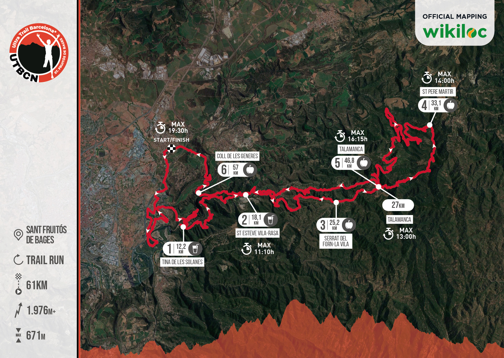
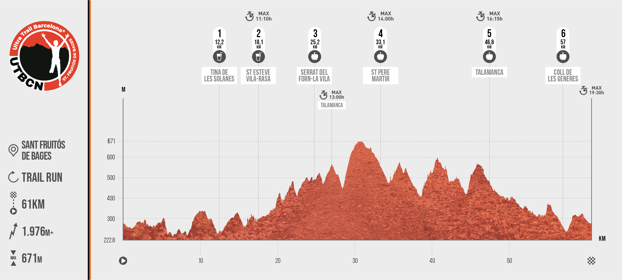
- 61 km
- 1976 M+
The circuit of the ULTRA distance proposes a route in a WEST-EAST direction until approaching, but without reaching Monistrol de Calders. The first part of the route, common with the rest of the distances, runs along the Llobregat river with views towards Els Tres Salts and then goes into the Ulls del Llobregat and the Mura stream from the ruins of the Tines Solanes. This section runs along the stream of Mura offering wide views of the entire sector and from Sant Esteve we enter a myriad of trails, either by the bottom of streams and streams or more aerial areas with wide views to the Collet de Cantagalls and from there to Talamanca. From here the hardest climb of the route takes us to the top of the Serrat de Cantagalls.
Leads us to the top of the Serrat de la Mussarra and from there in a northerly direction to the Ermita de Sant Pere Martir. At this point we start the route in EAST-WEST direction by the Serrat de Mumbrú back to Talamanca. From here the route follows the course of the Torrent de Güell in a descent of almost 9kms that will bring us back to Sant Fruitós de Bages after reaching the Coll de les Generes and crossing the Llobregat river by the bridge of the same name passing through Sant Benet de Bages.
A very varied route where most of the slopes do not exceed 200 meters and that will allow participants to discover an area where dry stone constructions, walls, huts and abandoned farmhouses, will remind us of the splendid agricultural past of the area.
Circular route with departure and arrival at the Castell de Castelldefels that starts heading west by the Serrat de la Covafumada towards La Morella (KM 7). Towards the north we will look for the Coll del Pou de le Burigues and the Pla de Solius (KM 13.5) where we will approach the Costeta de Begues until the Silla de Santo Cristòfol (KM 24) and towards Olesa de Bonesvalls passing through the Coll de Correscal. We will take direction East by the Forest of Montau and the mountains of the Ordal by where we thread up to the Puig de Saida (620 m). From here a descent to the Coll de la Creu de Ardenya and a climb to the Peña del Moro (467 m) to the south towards Bruguers where we will find the Castell de Eramprunyà, the Coll de la Clota and the last height of 551 m at its kilometric point 51 which will be the Puig de les Agulles, before the last descent back to the Castell de Castelldefels.
• Commemorative gift of the race
• Bib number
• Solid and liquid refreshments along the route
• Final refreshment at the finish line
• Signposted route
• Timing service
• Medical services
• Shower and changing room service.
• Finisher gift to all participants who complete the race.
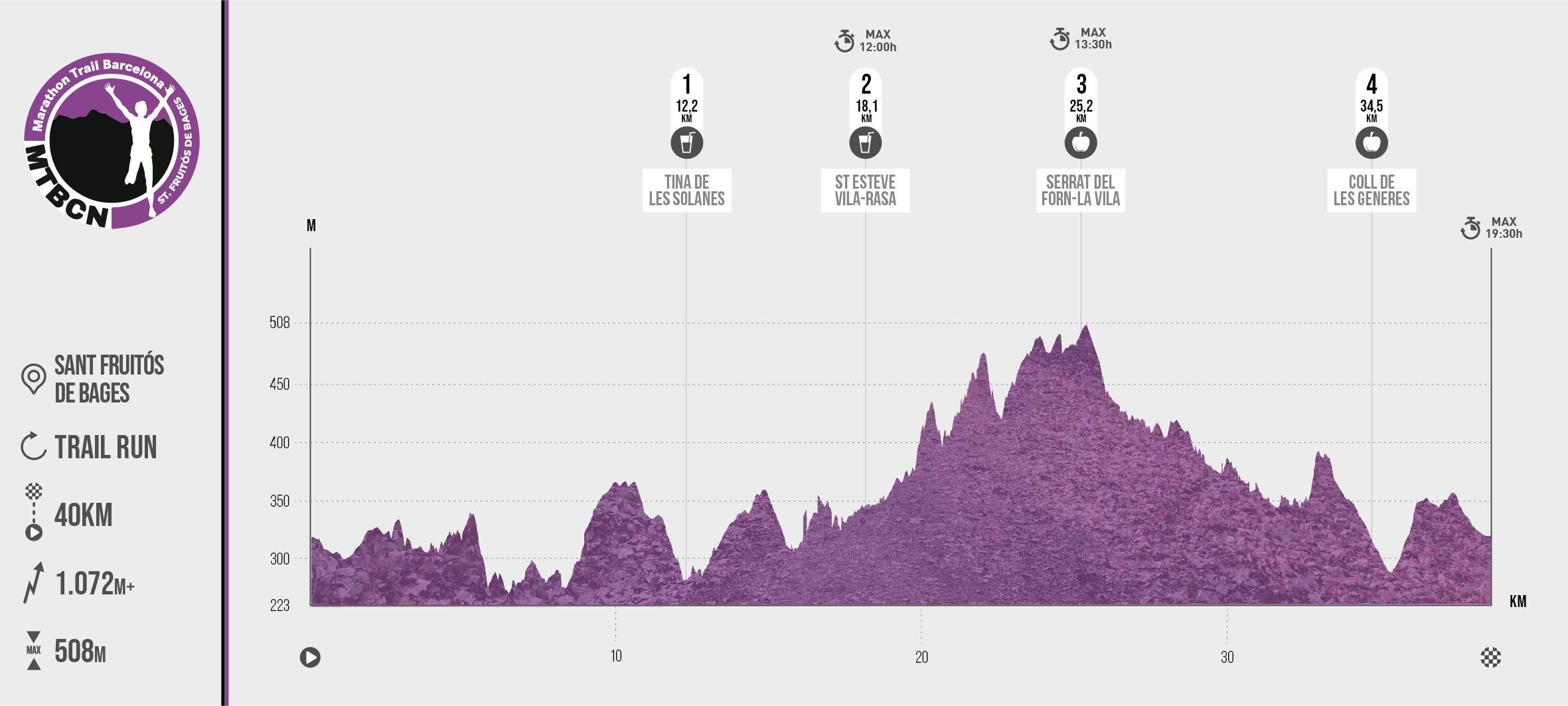
marathon
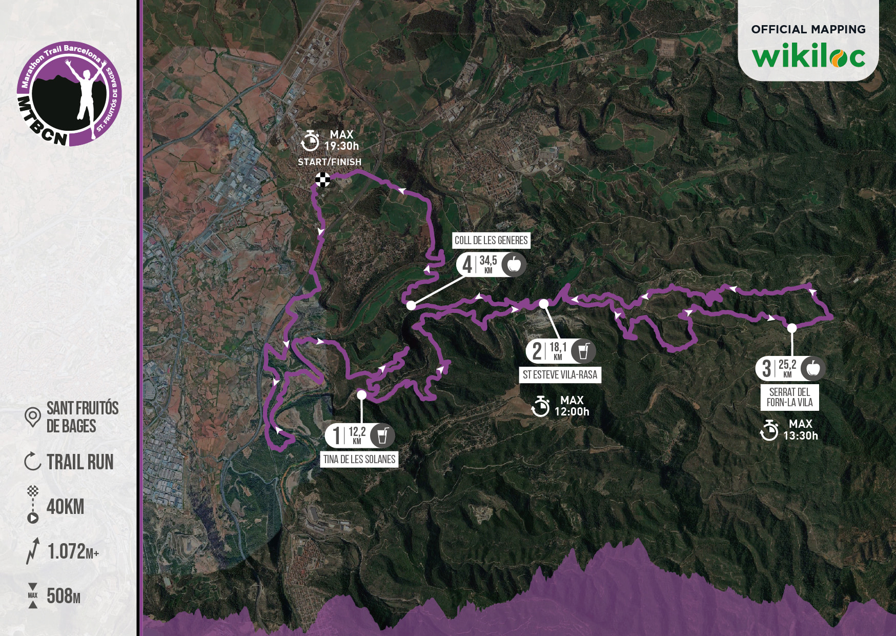
- 40 km
- 1072 M+
Circular route with departure and arrival at the Castell de Castelldefels that starts heading west by the Serrat de la Covafumada towards La Morella (KM 7). From here and towards the north we will look for the Coll del Pou de le Burigues by the Sierra de la Guardia and towards the Puig Verdeguer (515 m) and the Hucha (427 m). In slight descent we will arrive to Begues that we will cross by the zone of the Bassa Blanca (KM 21) and in north direction arrives to the Buen repós, where we will take Southeast direction towards the Roca del Barrita, the Vicaría and Bruguers (KM 27). From here a descent to the Coll de la Creu de Ardenya and a climb to the Peña del Moro (467 m) to the South towards Bruguers where we will find the Castell de Eramprunyà, the Coll de la Clota and the last height of 551 m at km 51 which will be the Puig de las Agulles, before the last descent back to the Castell de Castelldefels.
• Commemorative gift of the race
• Bib number
• Solid and liquid refreshments along the route
• Final refreshment at the finish line
• Signposted route
• Timing service
• Medical services
• Shower and changing room service.
• Finisher gift to all participants who complete the race.
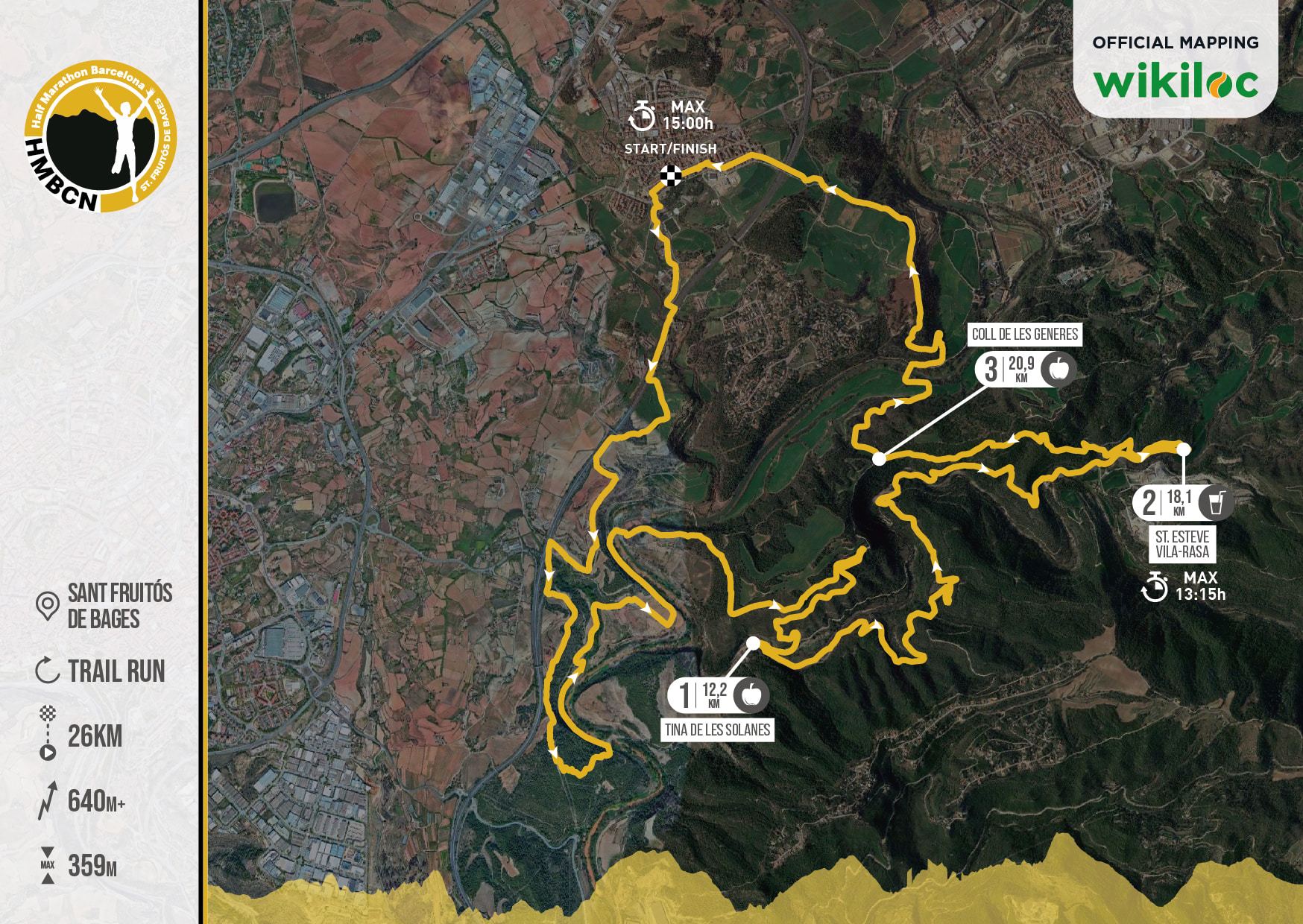
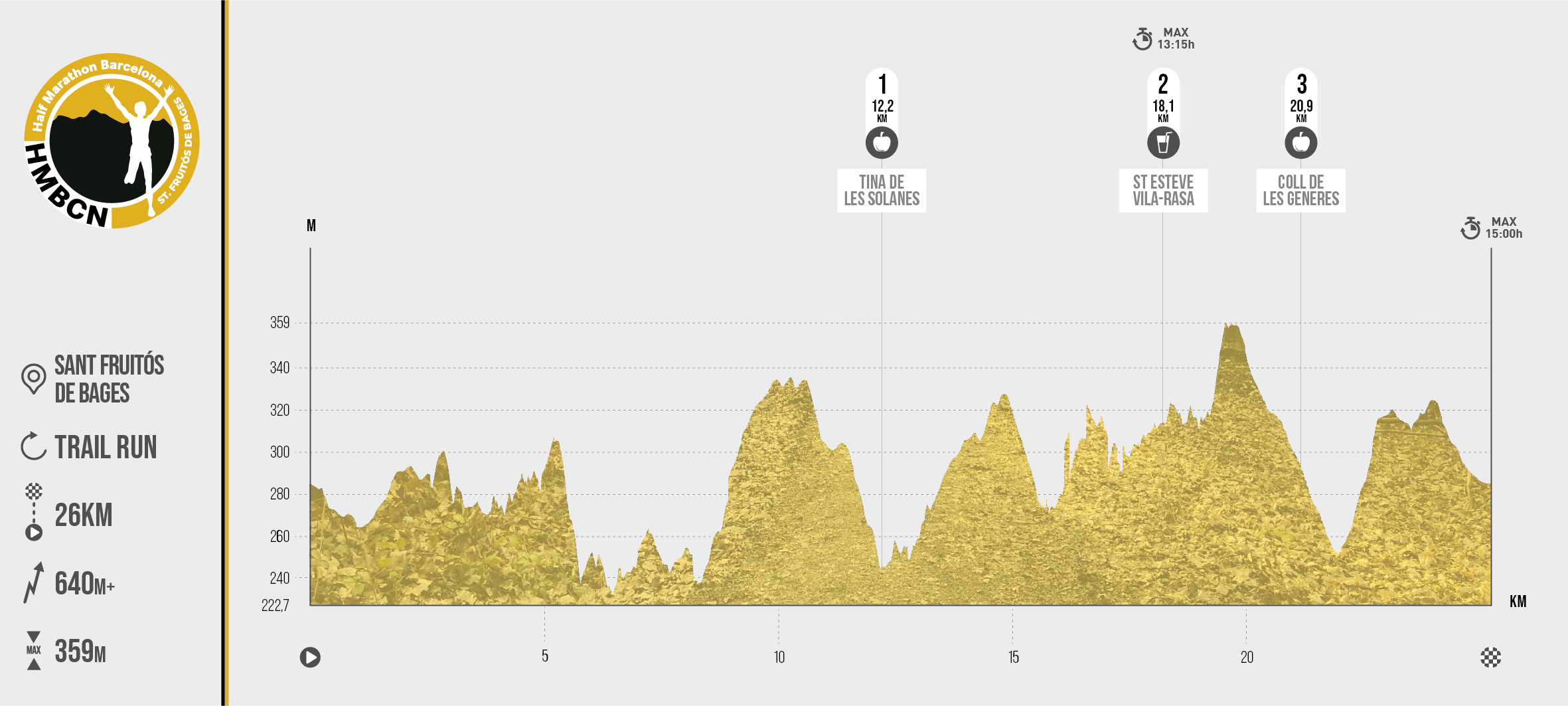
half marathon
- 26 km
- 640 M+
The circuit of the 26 KMS race proposes a route in SOUTH direction, following the Llobregat riverbed passing by the viewpoint of the Roca Tinyosa from where we can contemplate a spectacular view over the Llobregat river. From this point a rapid descent brings us closer to the Llobregat riverbed that we will cross passing by the Mirador dels Tres Salts and up to the Passera dels Ulls del Llobregat where we will cross to the other side of the river, starting an ascent to the Pla de les Generes where we will enjoy wide views. Arrived at the Tina de Les Generes. From there, a descent of 2 kms will bring us closer to the Tines de les Solanes and the bed of the stream of Mura, which we will follow in an easterly direction. Shortly after passing the Hermitage of Sant Esteve de Vilarasa, we will change direction again, reaching the maximum height of this route 360 meters, in the serrat de Sant Esteve.
From here the route continues in a northerly direction and will bring us back to Sant Fruitós de Bages after reaching the Coll de les Generes and crossing the Llobregat River over the bridge of the same name, passing through Sant Benet de Bages.
Circular route starting and finishing at the Castell de Castelldefels that starts heading west by the Serrat de la Covafumada passing through the Coll de Santa Maria, the Cerro del Fanxó (279 m), the Puig del Cèrvol (311 m) and the Puig de la Olla (429 m) towards La Morella (KM 7). Then we turn towards Coll Ssotrells and the Cruz de la Clota (KM 11). Heading east we reach the Balsa de los Vinyals (KM 15) and the Roble de Can Dardena (KM 16) after passing through the Sentís and return to the starting point.
• Commemorative gift of the race
• Bib number
• Solid and liquid refreshments along the route
• Final refreshment at the finish line
• Signposted route
• Timing service
• Medical services
• Shower and changing room service.
• Finisher gift to all participants who complete the race.
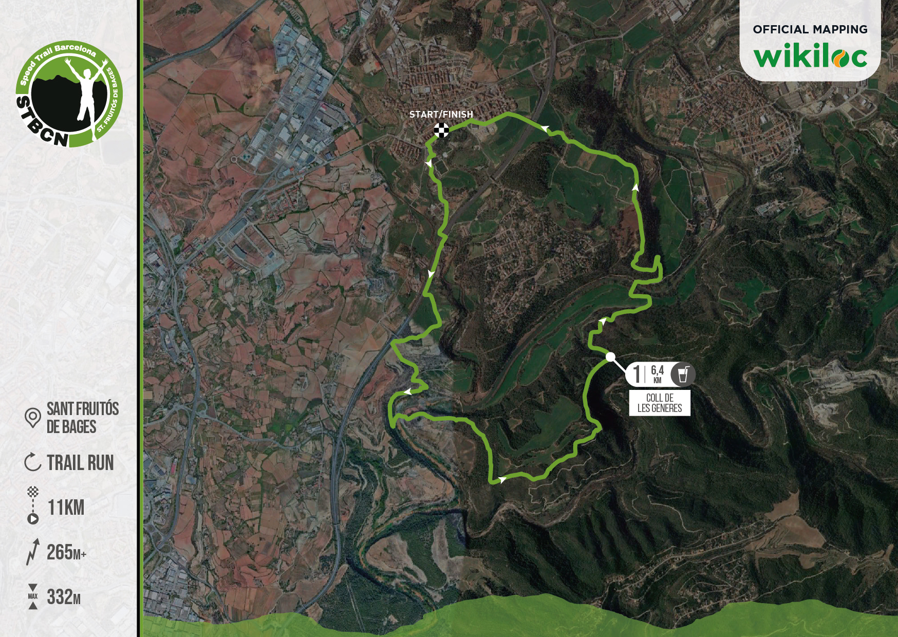
speed trail
- 11 km
- 261 M+
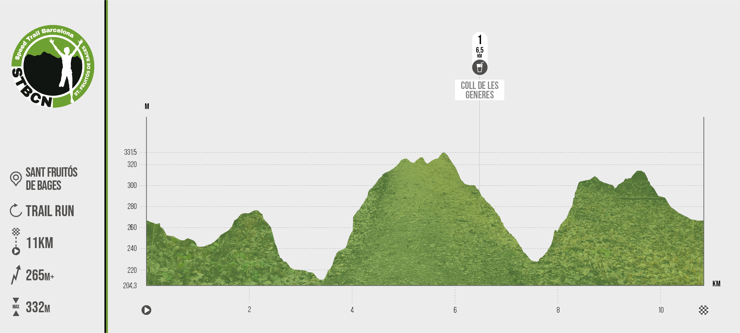
The circuit of the fastest race of the UTBCN proposes a route in SOUTH direction, following the course of the Llobregat river that at km 2 begins a descent to reach the Pont del Canal de la Mina and the Passera dels Ulls del Llobregat where we cross to the other side of the river, starting an ascent to the Pla de les Generes where we will enjoy wide views. From there, a 2 km descent will take us to the Tines de les Solanes and the Pont de les Generes at km 7.6 of the race.
From here the route continues in a northerly direction and will bring us back to Sant Fruitós de Bages after reaching the Coll de les Generes and crossing the Llobregat river over the bridge of the same name passing through Sant Benet de Bages.
A fast route to the southeast of Sant Fruitós de Bages and around les Brucardes with wide views over the Llobregat river and the stream of Mura.
Circular route with departure and arrival at Castelldefels Castle that starts westwards passing through Cal Ganxo, Cal Gall and Cova Perduda until reaching Coll de Santa Maria. From there the route turns in a northerly direction without gaining elevation until it turns again in a westerly direction, beginning the climb to the highest point in the direction of Las Penyes de l’Àliga without reaching its summit. A quick descent in a northerly direction to return along the Sentis to the starting point passing through Can Vinyes and the Rore de Can Dardena.
• Commemorative gift of the race
• Bib number
• Liquid refreshment along the route
• Final refreshment at the finish line
• Signposted route
• Timing service
• Medical services
• Shower and changing room service.
• Finisher gift to all participants who complete the race.
popular walk
- 6 km
- 79 M+
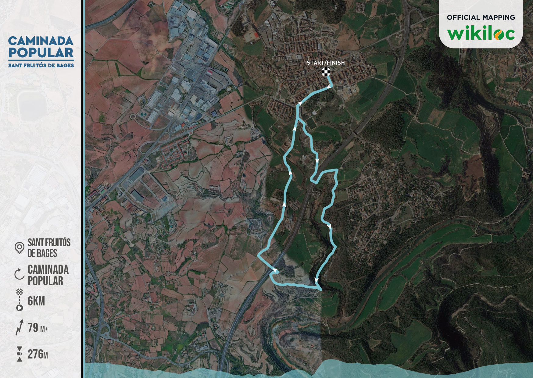
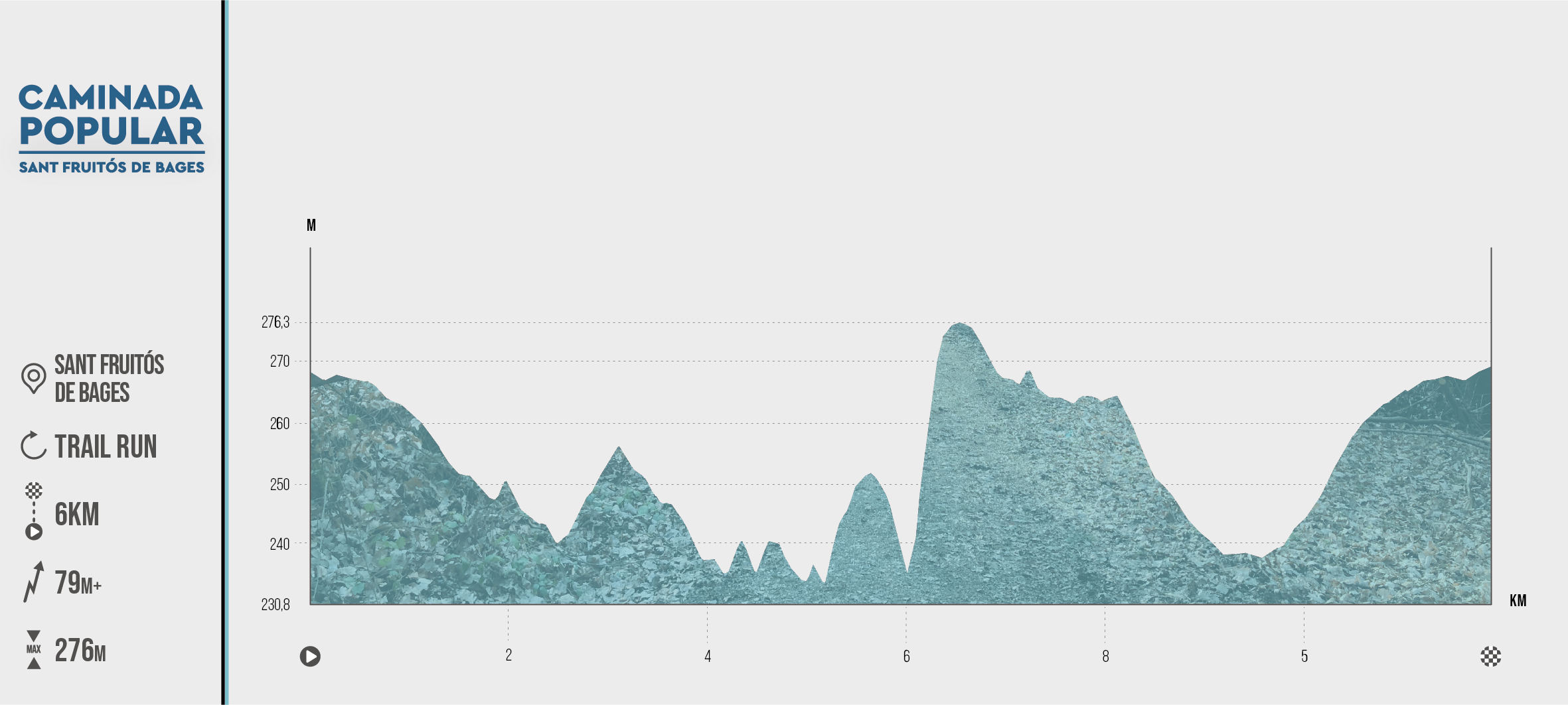
Circular route starting and finishing at the Castell de Castelldefels that starts heading west by the Serrat de la Covafumada passing through the Coll de Santa Maria, the Cerro del Fanxó (279 m), the Puig del Cèrvol (311 m) and the Puig de la Olla (429 m) towards La Morella (KM 7). Then we turn towards Coll Sotrells and the Cruz de la Clota (KM 11). Heading east we reach the Balsa de los Vinyals (KM 15) and the Roble de Can Dardena (KM 16) after passing through the Sentís and return to the starting point.
